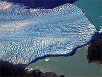
Caída del glaciar Perito Moreno Imagen: Agencias / Internet
Tamaño:
El glaciar Perito Moreno es compartido por Argentina y Chile y se extiende sobre el Brazo Sur del Lago Argentino, con un frente de cinco kilómetros de longitud y sesenta metros de altura, siendo este uno de los glaciares más imponentes del mundo. El Glaciar Perito Moreno tiene una velocidad medida, a unos 4 km del frente, de aproximadamente 2 m por día, alrededor de 700 m por año.
Este glaciar al represar las aguas del Lago Argentino provoca el aumento de nivel de las aguas del lago las cuales erocionan el frente del glaciar. Ensto crea un túnel con una bóveda de más de 50 metros por el que las aguas del Brazo Rico descienden hasta el Lago Argentino, la erosión causada por el agua provoca finalmente el derrumbe de la bóveda, en uno de los espectáculos más imponentes que puedan presenciarse. Este es un fenómeno natural no el resultado del supuesto calentamiento global.
Have you previously worked with or heard of RGSL and would like to know where RGSL has gone? Discover the link between RSGL and Reynolds International here.
Climbing Magazine"s Web site contains more than 30 years of rock and ice climbing news, climber profiles, technical information, and gear reviews. You"ll also find message boards, photo galleries, and classifieds
Scientific Working Group of the International Association of Cryospheric Sciences (IACS) and the International Permafrost Association (IPA). Department of Geosciences University of Oslo
The experience and data on glacier disasters in Switzerland has been systematically collected in the past two decades, and historical sources were analyzed.
The floods, known in Perú as aluviónes, come with little or no warning and are composed of liquid mud that generally transports large rock boulders and blocks of ice.
Glaciers online offers photos and summary explanations concerning glaciers from all over the world. The primary goal of our project is to enrich and stimulate the teaching of Earth Science and Physical Geography, in particular glaciology.. Jürg Alean & M
2026 Ciencia1.com - Ciencia y Tecnología. Permitida la reproducción siempre que se señale la fuente y enlace correspondiente a cada material info@ciencia1.com


 Imagen: Agencias / Internet