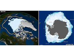
El desprendimiento de hielo, que sucediцЁ el pasado jueves y fue descubierto por el Servicio de Hielo Canadiense, es el mayor desde 1962 y se dirige hacia el estrecho de Nares, a unos 1 000 kilцЁmetros al sur del Polo Norte, entre Groenlandia y Canadц║.
El desprendimiento era un acontecimiento relativamente previsto, ya que el glaciar habцґa crecido de manera significativa en los ц╨ltimos siete u ocho aц╠os, aunque no se esperaba que el iceberg generado fuera tan grande. Los expertos estarц║n ahora alerta para ver si isla de hielo llega a tierra, se rompe en trozos mц║s pequeц╠os o se mueve hacia el sur, donde podrцґa provocar problemas en las rutas marцґtimas, segц╨n ha indicado Andreas Muenchow, profesor de Ciencias del Mar e Ingenierцґa en la Universidad de Delaware e investigador en la zona donde sucediцЁ el desprendimiento.
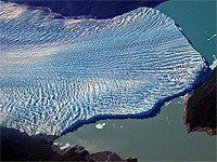
El iceberg mide 260 kilцЁmetros cuadrados y su grosor es de casi la mitad del rascacielos neoyorquino Empire State, de 102 pisos, ha explicado Muenchow. "El agua dulce que contiene esta isla de hielo podrцґa mantener el caudal de los rцґos Delaware o Hudson por mц║s de dos aц╠os" y "podrцґa tambiц╘n proveer a todos los grifos pц╨blicos estadounidenses de agua por 120 dцґas", ha aц╠adido el experto.
Segц╨n Muenchow, es difцґcil saber si el evento se debe al calentamiento global porque solo hay registros del agua salada alrededor del glaciar desde 2003. El flujo de agua salada bajo los glaciares es una de las principales causas de los desprendimientos de hielo de Groenlanda. "Nadie puede decir que esto haya sido causado por el calentamiento global. Pero tampoco nadie puede decir que no haya sido por ello", ha concluido.
Noticia completa en Diario Hoy (Ecuador)


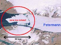
 Imagen: NASA