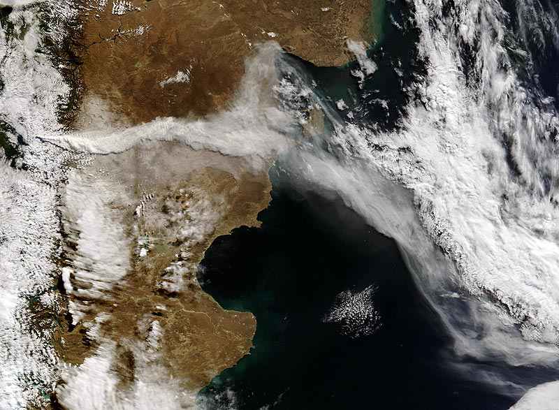
La imagen corresponde al satélite Terra de la NASA que observó la erupción del volcán Chaitén. Luego de iniciar la actividad, el penacho de cenizas se extiende sobre más de 2 000 kilómetros, atravesando el sur del continente americano, sobre Argentina y alejándose hacia el este, sobre el océano Atlántico.
El satélite Terra posee varios instrumentos, entre ellos el visor Modis (Espectroradiómetro de Imagen de Resolución Moderada) que registra una franja de 2.330 kilómetros de anchura en 36 bandas espectrales, que van del visible al infrarrojo.
Enlaces a sitios |
| |
Climate Audit by Steve McIntyre Climate Audit. Investigating the statistical methods used in climate science
| Climate Change Resources Explore the best climate change resources, from scientific reports to educational tools and take action guides. Stay informed and make a difference today.
|
Climate Debate Daily Is intended to deepen our understanding of disputes over climate change and the human contribution to it. The site links to scientific articles, news stories, economic studies, polemics, historical articles, PR releases, editorials, and blog entries
| Dr Roy Spencer Ph.D. in meteorology at the University of WisconsinMadison. Senior Scientist for Climate Studies at NASAs Marshall Space Flight Center, NASAs Exceptional Scientific Achievement Medal for their global temperature monitoring work with satellites
|
Historia del Clima de la Tierra En este sitio puedes ir saltando por mapas, gráficos y dibujos relacionados con diversos aspectos de los paleoclimas y de la historia general del clima. Por Anton Uriarte
| NCAS The National Centre for Atmospheric Science (NCAS) is a component of the Natural Environment Research Council (NERC), set up in 2002 to provide the UK with national capability in atmospheric science research and technology.. ,
|